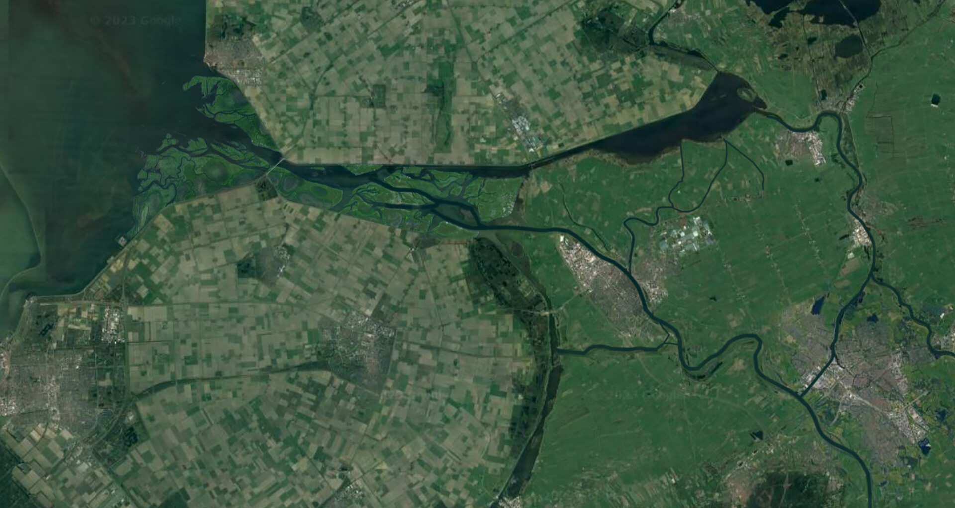
Impression of the Keteldelta | Photo: Jan Roozenbeek

Impression of the Keteldelta | Photo: Jan Roozenbeek
The IJssel-Vecht Delta is located where the IJssel and Vecht rivers flow into the IJsselmeer. This transitional water body faces a number of major challenges that require substantial investment, including the reinforcement of infrastructure via the Flood Protection Programme. There is also considerable pressure on available space and significant uncertainties for the future of the area, especially concerning the future water level of the IJsselmeer. If we continue to stick with the status quo for flood protection, will that deliver the desired result? In other words: are we actually doing the right thing?
Challenges
The area around the Ketelmeer, at the transition between the IJsselmeer, the IJssel and the Vecht rivers, is influenced by both the water levels in the lakes and the discharges from the two rivers. Its location makes the area unique: a freshwater system without tides, subject to two water boundaries. Under extreme conditions, westerly storms drive water levels and waves from the IJsselmeer under the Ketelbrug (the A6 motorway) and into the Ketelmeer, towards the mouths of the IJssel and Vecht. Water levels can also rise due to high river discharges. Climate change is leading to more extreme weather and greater uncertainty in how the water levels will change in the future.
Nature in the Ketelmeer is also under pressure. The area is largely a deep, uniform body of water with steep banks, with no transition or buffer zones between land and water. There very few places where animals can reproduce, take shelter and find food. Consequently, a robust food web fails to develop – partly due to a lack of organic matter. The WFD status of aquatic insects and fish is moderate, and the land cover and ecological quality of various Natura 2000 habitats and species are also inadequate. The Programmatic Approach to Large Water Bodies (PAGW) therefore aims to implement a large-scale systemic intervention that will result in robust natural areas with greater habitat diversity and more space for natural processes [1].
Keteldelta
For centuries, the IJssel-Vecht Delta grew as a result of natural sedimentation. These processes have been disrupted by human intervention, particularly the creation of the Flevopolder. The mouth of the IJssel is now physically located near the Ketelbrug when the river is in flood. In a natural system, the Ketelmeer would be shallower, would gradually silt up, and a new delta would form around the Ketelbrug.
The Keteldelta concept (devised by Bert Bijkerk) is an innovative spatial concept for a forward-looking design of the Ketelmeer and the eastern IJsselmeer. It represents a systemic shift: a scalable and adaptive approach that brings together flood risk management, habitat creation, ecological water quality, recreation, climate adaptation and freshwater availability, whilst preserving the highly productive agricultural land on Kampereiland.
The creation of marsh areas, islands, natural banks, shallow areas and channels would result in a dynamic water system that provides space for both water and nature. As well as benefiting nature and flood defences, the concept also offers opportunities in other areas such as shipping, recreation, sustainability and energy. Instead of piecemeal measures, the Keteldelta concept proposes a systems thinking approach: a holistic vision that aligns with natural processes, creates synergy between objectives, and works towards an adaptive design that can evolve in line with climate change. The aim is a transformation to a robust, resilient and future-proof water landscape.
Flood risk management
Water levels in the lakes (which are raised significantly during storm surges and high winds) and river discharge are the two main factors driving the hydraulic pressure on the primary flood defences in the area. Keteldelta can help reduce water levels and wave heights, thereby reducing the requirements for future reinforcement work. The potential was investigated in two ways: through numerical model simulations using flow velocity and wave models, and through physical scale experiments.
Numerical model simulations show that the Keteldelta concept has potential [2]. Even with a simple design comprising islands in front of the Ketelbrug and within the Ketelmeer itself, water levels can be lowered by as much as 0.2 to 0.3 metres and wave heights significantly reduced. As this will benefit potentially dozens of kilometres of primary flood defences, the costs of future dike reinforcements will therefore be reduced. Future crest heights could be several to many decimetres lower than at present [3].
In addition, the viability of a special island design was investigated. Further optimisation is possible by creating islands in a series of crescent shapes (see Figure 1). These ‘Tesla valves’ are not a new concept but have never been implemented on such a large scale before.
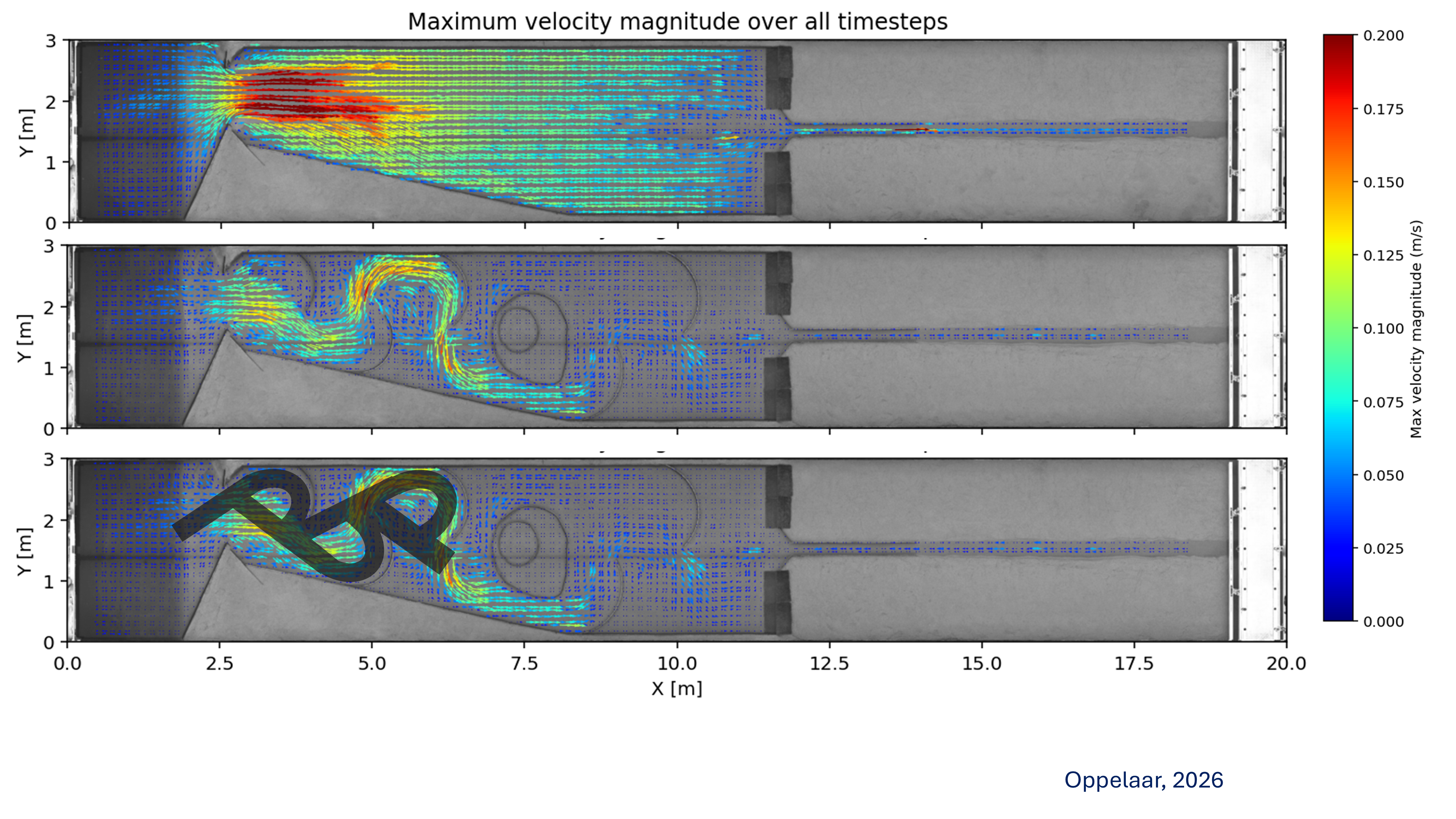 Figure 1. Simulation of flow velocities in a scale model of the Ketelmeer with and without Tesla valves (top two figures). The maximum flow velocities as the storm surge passes are shown. The water flows from left (IJsselmeer) to right (IJssel); the narrowing at the Ketelbrug is on the left, at X = 2.5. The bottom figure shows a schematic representation of the Tesla valve concept
Figure 1 clearly shows that flow velocities are significantly lower in the configuration with Tesla valve islands. The unique island configuration allows water to flow freely in one direction, whilst restricting the flow in the other. This slows down storm surges from the IJsselmeer, whilst allowing high discharge volumes from the IJssel and Vecht to flow away relatively unhindered – which is beneficial for flood defences, as storms in the IJssel-Vecht Delta pose the greatest threat.
The Tesla valve concept was tested using scale experiments in the ‘Metronome’, a tilting tidal flume in the Earth Simulation Laboratory at Utrecht University [5]. The Ketelmeer was recreated in the flume of 20 x 3 metres, with varied configurations in the number, angles, width, length and location of the islands. A number of realistic storm scenarios were then simulated for each configuration. The experiments show that the inland surge is reduced in all cases where islands are present, with reductions of 20% to 50% for different types of storm surges. The closer to the boundary with the IJsselmeer that the valves are installed, the bigger the reduction. Furthermore, the Tesla valve configuration creates areas of low flow around the islands, which is important for the development of new ecotopes.
Nature and ecology
As it is a dynamic transition from river to lake, the Ketelmeer has potential for high biodiversity. Flood-prone islands near the mouth of the IJssel will develop into river islands with naturally regenerating riparian forests (see Figure 2). Islands closer to the IJsselmeer, which would have a more dynamic character, form a more open delta landscape. Both types of water body offer a wide range of habitats: deep channels, shallow riparian zones, sheltered waters, marsh vegetation, scrubland, riparian forests and open pioneer grasslands.
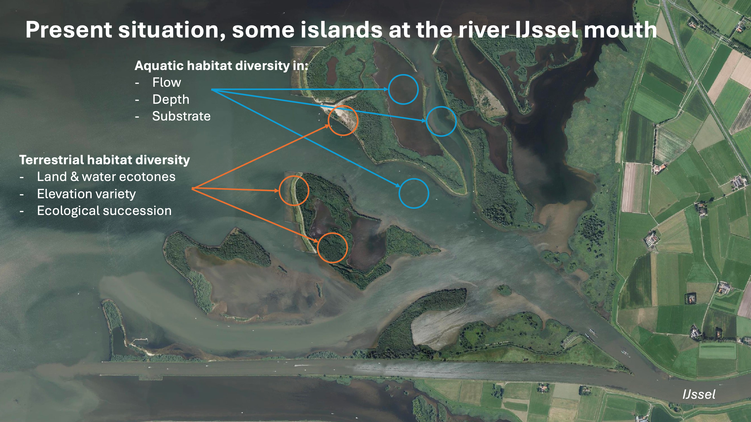 Figure 2. At the current mouth of the river. The variation in habitat (wet and dry) is clearly visible here. In terms of their character, the islands are similar to river islands.
The requirements for wetland habitats vary in terms of current speed, water depth and substrate type. In drier areas, the variation consists of transitions between wet and dry conditions, and exposure to wind and waves. The final shape of the islands, which are yet to be designed, is – as is typical of nature-based solutions – will be a case of balancing flood protection and shipping requirements, and the maximum permissible wind dynamics, hydrodynamics and morphodynamics. Together, they form a robust ecosystem with habitats for breeding, foraging and shelter both above and below the water. The vegetation and the interaction between wet and dry areas produce organic matter, which strengthens the food web of the IJsselmeer region as a whole.
Conclusions
An integrated solution
The Keteldelta concept is based on the natural principle of delta formation and serves a number of social objectives. It has the potential to significantly reduce water levels and wave heights and to address climate uncertainties and future flooding risk. The result: savings on future dike reinforcements. At the same time, the development of new land-water transition zones offers opportunities for dynamic ecosystems and synergies with other functions, such as shipping, recreation, freshwater and drinking water supply, and energy.
Scalable and adaptive
The Keteldelta concept represents a paradigm shift that responds to changes in climate, spatial planning and policy. It enables a scalable and flexible approach: depending on how things evolve, the idea can be further developed and adapted from a small scale to an increasingly larger one.
Follow-up research
Based on our experiments (both numerical models and scale experiments), there is no doubt that Keteldelta has potential. Given the many variables and possibilities within the concept, further research is needed before concrete design decisions can be made. A phased approach that involves transitioning from a small to a larger scale (depending on climate and spatial developments) is feasible and provides useful starting points for further research.
The IJssel-Vecht Delta is under pressure, both in terms of land use and as a result of climate change. The innovative 'Keteldelta' concept offers a solution. Smart design in the Ketelmeer can create a natural buffer for flood protection, combined with thousands of hectares of new nature. Numerical models show that the concept can significantly reduce water levels and waves during storms. Scale experiments confirm that the Tesla valve principle also works on a large scale. This system solution transforms the area from a vulnerable storm basin into a robust delta that can be expanded and adapted, thereby laying a future-proof foundation for flood protection, ecology and other functions in the region.