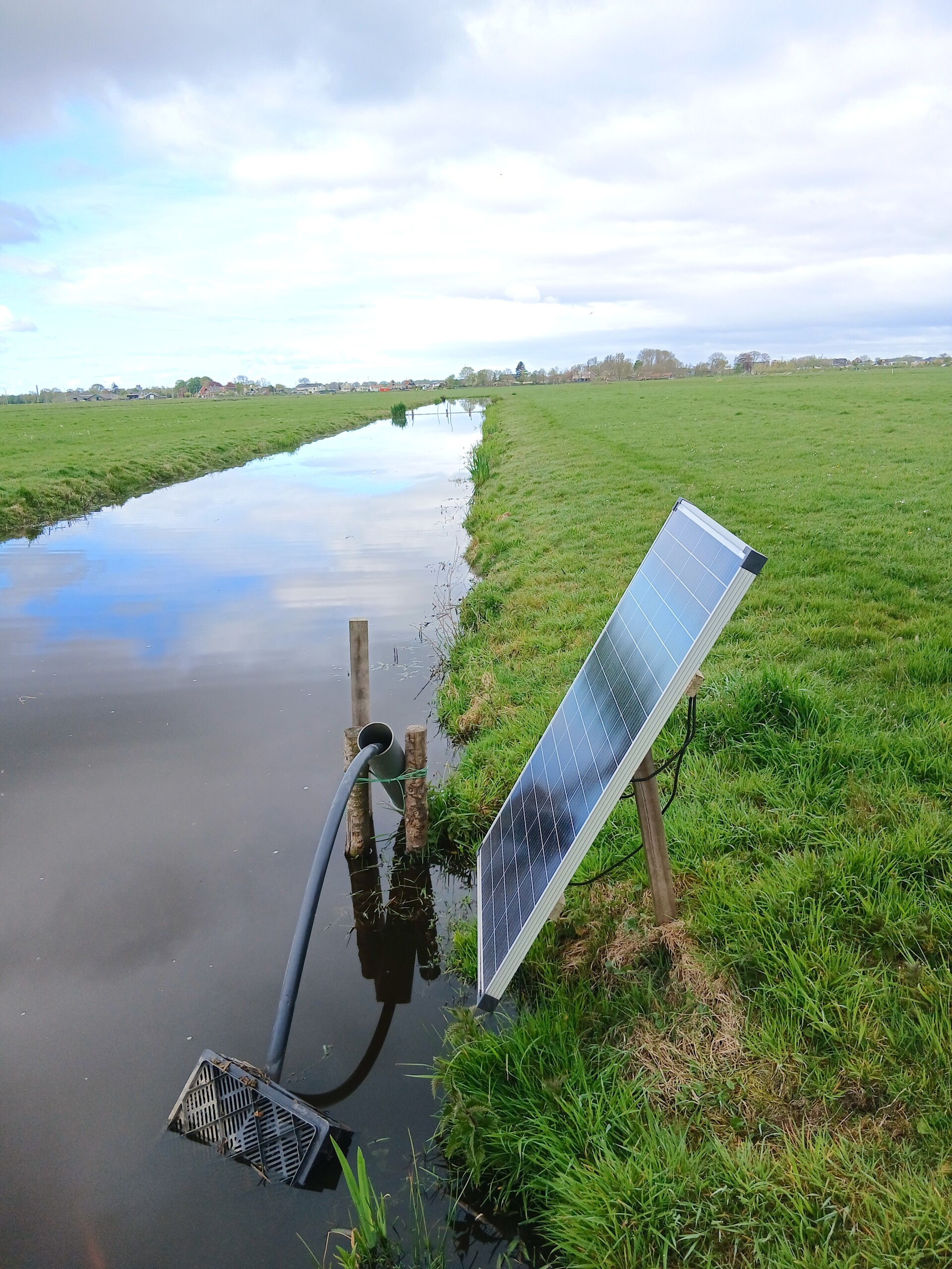
Photo: Sander Roeleveld

Photo: Sander Roeleveld






Peat oxidation not only leads to land subsidence, but also to greenhouse gas emissions and the eutrophication of surface waters. Several organisations such as the Netherlands Research Programme on Greenhouse Gas Dynamics in Peatlands and Organic Soils (NOBV) and the Foundation for Applied Water Research (STOWA) have spent years experimenting with measures to combat this process. Their overall aim is to raise the groundwater level to prevent peatland oxidation, particularly in the summer. Research has hitherto focused mainly on the effectiveness of water infiltration systems (WIS) in peatlands, which rely on underground drainage pipes to raise groundwater levels in plots, sometimes passively but usually with the aid of pumps [e.g. 5, 7]. WIS can be effective in combating land subsidence, but due to the high installation costs, these systems are not yet introduced on a large scale. In addition, these systems have been associated with a negative environmental impact of having more plastic pipes in the ground, certainly in the long term.
With a cost price of approximately €300-400 per hectare, infiltration via furrows is 20 times cheaper than the installation of WIS (approx. €7,000/ha [7]). Two separate studies have shown that furrow infiltration can be effective, but also that the distance between ditches must be very small (approx. 6 m) in order to achieve sufficiently high groundwater levels [5,6]. This would make it an impractical measure for farmers. However, both studies were carried out in areas where the peat was not covered by a mineral top layer. The plots were also grazed, meaning that the cows partially trampled the furrows. Much of the grassland in the Netherlands is only mown, and almost half of the country’s peatland area is covered with an anthropogenic top layer consisting of sand, clay and organic matter [3]. For plots without grazing in peatland areas with such a top layer, furrow infiltration may therefore be a viable solution.
The main question of our research is therefore: can furrow infiltration in peatlands with a sandy top layer be used to maintain a high groundwater level across the entire plot throughout the year? And if so, what are the implications for soil levels, emissions and farming practices?
Method
Our infiltration trial began in July 2024 in the Vrouwe Vennepolder (the ‘Polderlab’, see www.polderlab.org) near Oud Ade, and ran until early 2026. The area is managed by the citizen’s collective ‘Land van Ons’, and its overall aim is to develop a future-proof, nature-inclusive approach to managing the peatland area. The peat layer at this site is approximately 1.5 metres thick and consists mainly of meadow peat (reed, sedge or fen peat [3]). It has an anthropogenic top layer: a layer of soil, approximately 30-35 centimetres thick, that has been built up by human activity over the course of a few hundred years. It consists of a mixture of sand, silt, clay and organic matter (58, 23, 11 and 7 percent respectively). The Polderlab is situated around 2 metres below sea level, and has a flexible ditch water level, which fluctuated between approximately 30 centimetres (summer) and 36 centimetres (winter) below ground level in 2024-2025. Since 2021, the ditch water level has been gradually raised by 12 centimetres.
The trial involves two ungrazed plots of 1.3 hectares, one with and one without infiltration furrows (figure 1). The trial plot has five furrows of the same depth (approx. 25 cm), spaced 12 metres apart. This distance makes agricultural operations, such as mowing and fertilising, perfectly feasible. Between 1 March and 1 October, all the furrows were filled with a shallow layer of water using a solar-powered pump. It pumps water from the ditch into an underground pipe (10 cm in diameter) that connects the furrows in the trial plot along the north-south axis. The system is designed so that all furrows are filled with a layer of water 2 to 8 centimetres deep. No records were kept of how much water was pumped into the furrows; this will be examined in a follow-up study. In both winters, the furrows were cleared in accordance with standard maintenance procedures. The control plot is slightly wider (82 metres compared to 64 metres for the trial plot) and has one central ditch for draining excess rainwater in winter.
Four monitoring well pipes with a 0.5-metre filter section were installed in the trial plot at a depth of 2.0 metres, exactly halfway between two furrows, with the furrows at a distance of 6 metres on either side (see figure 1). Two monitoring wells were installed at similar locations in the control plot, at 18 and 50 metres from the ditch respectively. Groundwater levels in all monitoring wells were measured manually at least once every two months throughout the year.
To determine the CO2 emissions of between the furrow infiltration plot and the reference plot, one-off measurements were carried out in September 2025 using manual flux chambers, positioned at each monitoring well. To assess the effects at ground level, elevation surveys were carried out using a drone in 2025. The resulting image has a horizontal resolution of 2 centimetres and a vertical resolution of 5 centimetres.
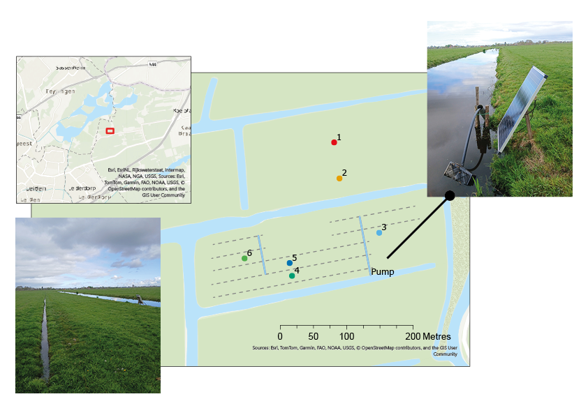
Figure 1. Field set up : the furrow infiltration field (bottom field) with four monitoring wells, and the control field (top) with two monitoring wells. The blue lines indicate the connecting pipes between the furrows. Only the northernmost furrow (near monitoring well 6) drains into a ditch. All furrows are filled with 2-8 centimetres of water.
Groundwater levels in the furrow infiltration plot were on average more than 30 centimetres higher than in the control plot, and ranged between 10 and 36 centimetres below ground level (average -24.7 cm ± SD 5.08 – see figure 1). In the control plot, this ranged from 11 to 115 centimetres (average -56.2 cm ± SD 29.9), with a groundwater level of 105-115 centimetres below ground level in September 2025. This means that in the control plot, beneath the top layer, a 75-centimetre layer of peat desiccates and is susceptible to oxidation.
Whilst groundwater levels in the trial plot were consistently higher in summer, the situation in the winter of 2024-2025 was exactly the opposite. During this period, the furrows in the trial plot functioned more as drainage, and the groundwater level remained stable around the level of the furrows. Remarkably, the groundwater level in the control plot behaved almost independently of the water level in the main ditch (figure 2). As expected, the infiltration from the elevated ditch water levels was therefore insufficient to compensate for evaporation and seepage in the centre of the plot.
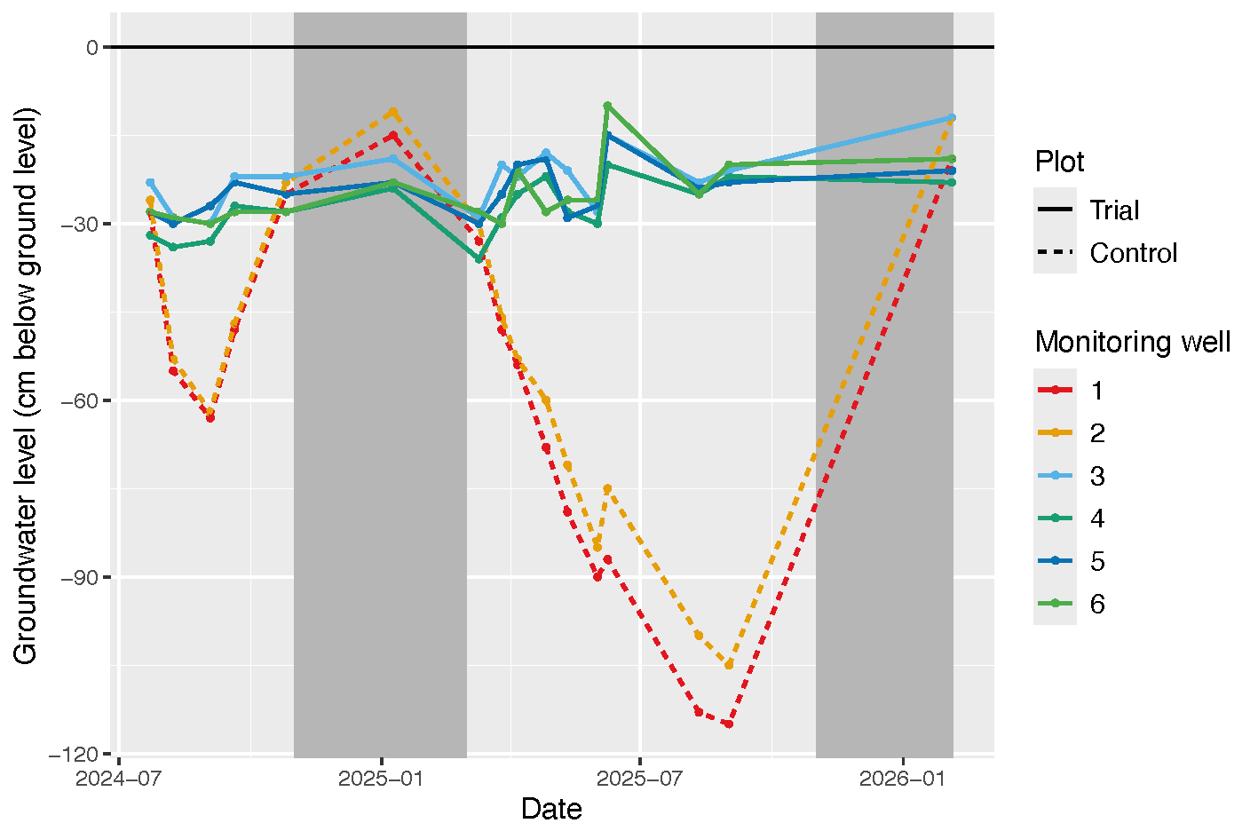 Figure 2. Groundwater levels in the furrow infiltration plot (monitoring wells 3-6) and the control plot (monitoring wells 1-2) (cm below ground level). The black ‘zero line’ indicates ground level. The dark grey areas show the period of winter water level in the ditch (-36 cm), whilst the light grey areas show the summer water level (-30 cm).
The furrows posed no a problem during mowing, apart from one small wet patch (approx. 2-3 m2). The dairy farmer mowed right next to the furrows using a standard heavy-duty mower, and has done so without any problems to date.
There were significant differences in ground level between the trial plot and the control plot (see figure 2). After just over a year, the trial plot was on average 12.1 centimetres higher than the control plot (SD 5.4). At the start, this difference was only 4.2 centimetres (SD 3.9). In addition, CO2 emissions were 25 percent lower in the furrow infiltration field.
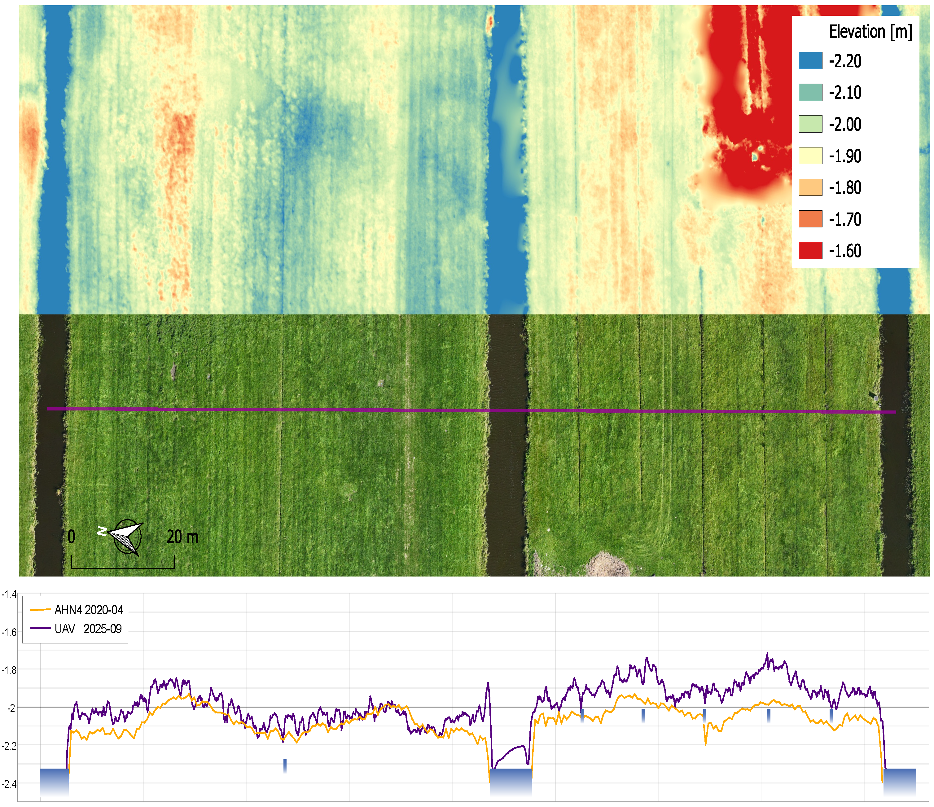
Figure 3. UAV orthophoto with accompanying drone image and ground levels [m -NAP] from September 2025. The ground level in the trial plot was on average 12.1 cm ± SD 5.4 cm greater than in the control plot. Before the start of the trial, this difference was 4.2 cm ± SD 3.9 (AHN4, 2020).
Discussion and Conclusion
Although our results were based on a small unreplicated field experiment, the findings are encouraging. They shed new light on a measure that has so far received little attention. The chosen method of furrow infiltration has proven effective in raising and maintaining the groundwater level. Simply raising the water level in the main ditch (in the control plot), on the other hand, was found to be far less effective. In the trial plot, CO2 emissions were reduced and the drop in ground level was limited. The latter is likely due primarily to the ‘swelling’ of the peat layer and less to differences in peat oxidation [8].
The success of this trial is probably partly due to the composition of the anthropogenic top layer. The combination of the sandy texture and the lack of grazing is likely to be a key factor. Together with bioturbation caused by worms and root growth, this anthropogenic top layer ensures that the soil is aerated and permeable, allowing water from the furrows to flow easily across the plot. This makes it possible to space the furrows further apart, thereby facilitating their integration into conventional farming practices. Previous studies have shown that furrows are often trampled by livestock [5], which reduces their effectiveness and requires more maintenance. Further research is needed to determine whether a combination of furrow infiltration and grazing is feasible and what maintenance will be required in the long term.
In conclusion, the study shows that furrow infiltration, a significantly cheaper measure than WIS, can be effective in raising groundwater levels in peatland in areas with a sandy top layer where there is no grazing. This would make it an effective and readily implementable measure for reducing land subsidence and emissions. Follow-up trials and trials on soils with different compositions (with and without a top layer) are needed to further validate the results of this study.
Land subsidence in peat soils is primarily caused by low groundwater levels during the growing season and can reach up to one and a half centimetres per year. This is happening at an ever-increasing rate due to increasingly hot and dry years. Higher groundwater levels are needed to slow down land subsidence. In recent years, there has been a great deal of focus on water infiltration systems: buried pipes combined with a pump system (active WIS). In this article, we present the results of a field trial involving furrow infiltration on ungrazed peatland plots with a sandy topsoil layer. Groundwater levels remained stable at 20-30 centimetres below ground level over the course of two summers, which is likely to have largely halted land subsidence caused by peat oxidation. The bearing capacity of the soil remained largely unimpaired: the farmer was able to mow and fertilise without any problems. We show that furrow infiltration can be effective and recommend that it be considered as a serious alternative to WIS in combating land subsidence.