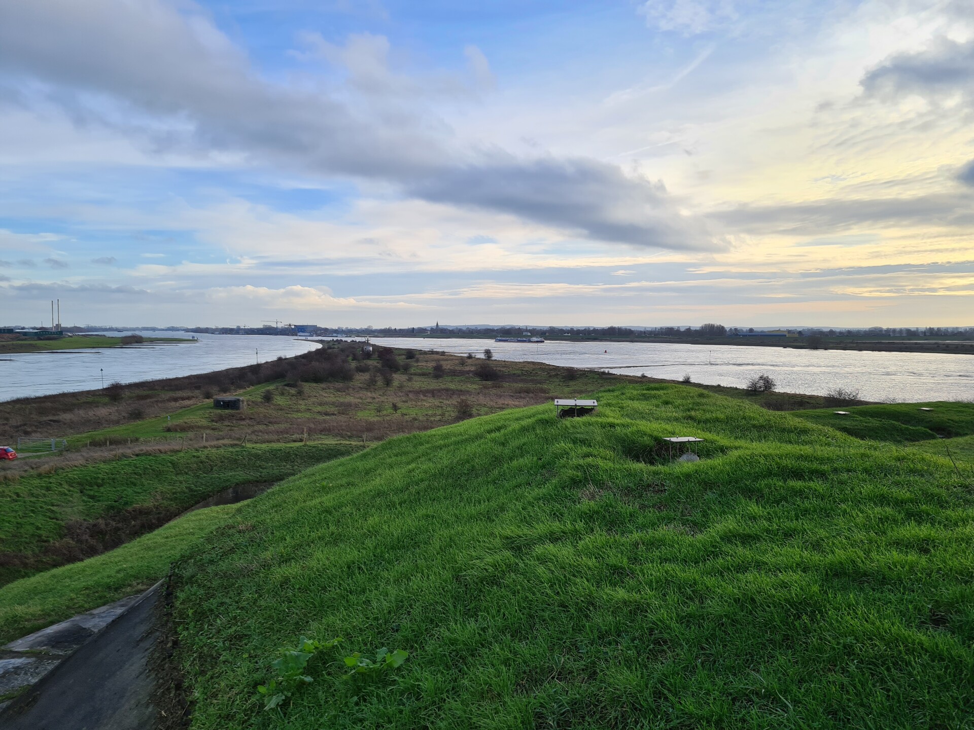
Bifurcation of the Rhine at Pannerden | Photo: Wageningen University & Research

Bifurcation of the Rhine at Pannerden | Photo: Wageningen University & Research




The Dutch government launched the first ‘Living with Water’ campaign back in 2003. The Netherlands needed to make more room for rising water levels instead of fighting against water. The ‘multi-layer safety approach’, which focuses on flood prevention, resilient spatial planning and well-prepared evacuation, was introduced in the National Water Plan in 2009. Successful projects and innovative pilot schemes have since been carried out. For example, flood-tolerant agricultural areas have been created in the Noordwaard in the Biesbosch, and various functions have been combined with flood defences, such as an attractive promenade with a reinforced flood barrier at Scheveningen.
Nevertheless, a study conducted in 2023 found that multi-layer safety measures are being implemented in only 5% of current flood protection projects [1]. Obstacles include a lack of financial and legal frameworks, as well as clear methods for integrating long-term water management objectives into short-term spatial planning objectives.
Part of the answer was the NL2120 approach. This approach views climate adaptation less in terms of risks and threats, and more in terms of opportunities, nature-based solutions and attractive prospects [2]. Nature-based solutions (NBS) for climate adaptation challenges were intended to make the Netherlands beautiful, water-rich and green. The vision was replicated at regional, local and even European level [3]. The design-based approach using NBS and a positive perspective offered opportunities to better integrate water management objectives into spatial planning. In the Flood-Resilient Landscapes project presented here, this was combined with expertise on flood protection and freshwater supply. The aim was to develop a methodology that enables public authorities and their land-use advisers to make sound decisions that take into account the natural characteristics of the area as well as long-term climate change.
Flood-Resilient Landscapes methodology
In the Flood-Resilient Landscapes project, we combine spatial planning studies, policy analysis and climate expertise with the local knowledge of the stakeholders involved, using a design-led research approach.
The method is carried out in a series of six ‘area workshops’. Participants in these workshops follow a structured process: an introductory session and collective definition of the area, policy and area analysis, futures study through ‘narratives’ (see below), selection of spatial planning and technical building blocks for the future visions, development of transformation pathways towards the future visions, and reflection on the implications for current policy and strategy. This process enables integration of both technical expertise and local insights, and to translate visions of the future into practical decisions.
A key element of the approach is the narrative method [4]. Narratives describe potential social developments and changing values. By drawing on a wide range of narratives, participants are encouraged to explore the ‘cornerstones’ of possible futures. One example is the protectionist narrative: independence and the protection of the existing culture, natural environment and economy. Another is the ecocentric narrative: a society that places the ecosystem at the heart of its thoughts and actions.
For each narrative, building blocks are selected that contribute to flood risk management, freshwater availability, flood prevention and spatial quality. These building blocks are translated into coherent future visions. In the next step, the complete set of building blocks for each development direction is mapped out over time on a transformation pathway.
Transformation pathways provide insight into how we can work step by step towards a vision of the future, and which choices we make along the way will determine our future options. Intervention points indicate when existing systems are not functioning adequately anymore, providing a deadline for implementing measures. Organising these elements visually provides insight into feasibility, risks and potential points at which there still is an option to switch between strategies.
Based on the six workshops, the various steps of the methodology have been made available in publicly accessible guides [5]. A comprehensive report on these and other regional case studies is available [6].
Regional case study: bifurcation area
The methodology has been applied to the bifurcation area between Arnhem and Nijmegen. This area where the Rhine bifurcates is important for the freshwater supply of the Netherlands, as it determines how much water flows into the Waal and how much into the IJssel to replenish the freshwater supply in the IJsselmeer.
The partners met for the first time at the first workshop: the Ministry of Infrastructure and Water Management, the Province of Gelderland, the Rijn en IJssel Water Board, the Rivierenland Water Board and the knowledge partners. During a visit to the area, they noted that, in addition to flood protection and freshwater availability, housing, shipping and biodiversity are key issues. In the second step, an area analysis was carried out using the layers approach [7]. Analysis of the subsoil shows that the course of the rivers in this area has changed on a regular basis. The Waal is a key shipping route within the network layer, and major railways and motorways also run through the area. The floodplains are largely nature reserves and store water during periods of high flow. Rapid urbanisation is a striking feature of the occupation layer. This area, which was originally the very dynamic home of the river, has largely been reclaimed and is now used for housing and agriculture. The impact of an extreme climate scenario for the year 2100 has been assessed for the existing landscape around the bifurcation area. Large parts of the area are at moderate risk of flooding (approximately once every 100 years). Agricultural areas are at increasing risk of drought stress.
In the third step, variants were developed using the narrative method. Discussions with local partners revealed three narratives for the bifurcation area: protectionist, ecocentric and ecomodernist. These narratives have been developed into engaging ‘stories’ that address the challenges of flood risk management, flooding and freshwater availability. In workshop 4, these stories were given a spatial dimension by representing them on maps as part of research by design. To address the climate challenges, building blocks were selected that fit a narrative. These building blocks are technical solutions, nature-based or otherwise, for water management objectives. The three solutions are shown in Figure 1. The designs are not definitive plans of ‘what will happen’, but thought experiments exploring ‘what might be possible’.
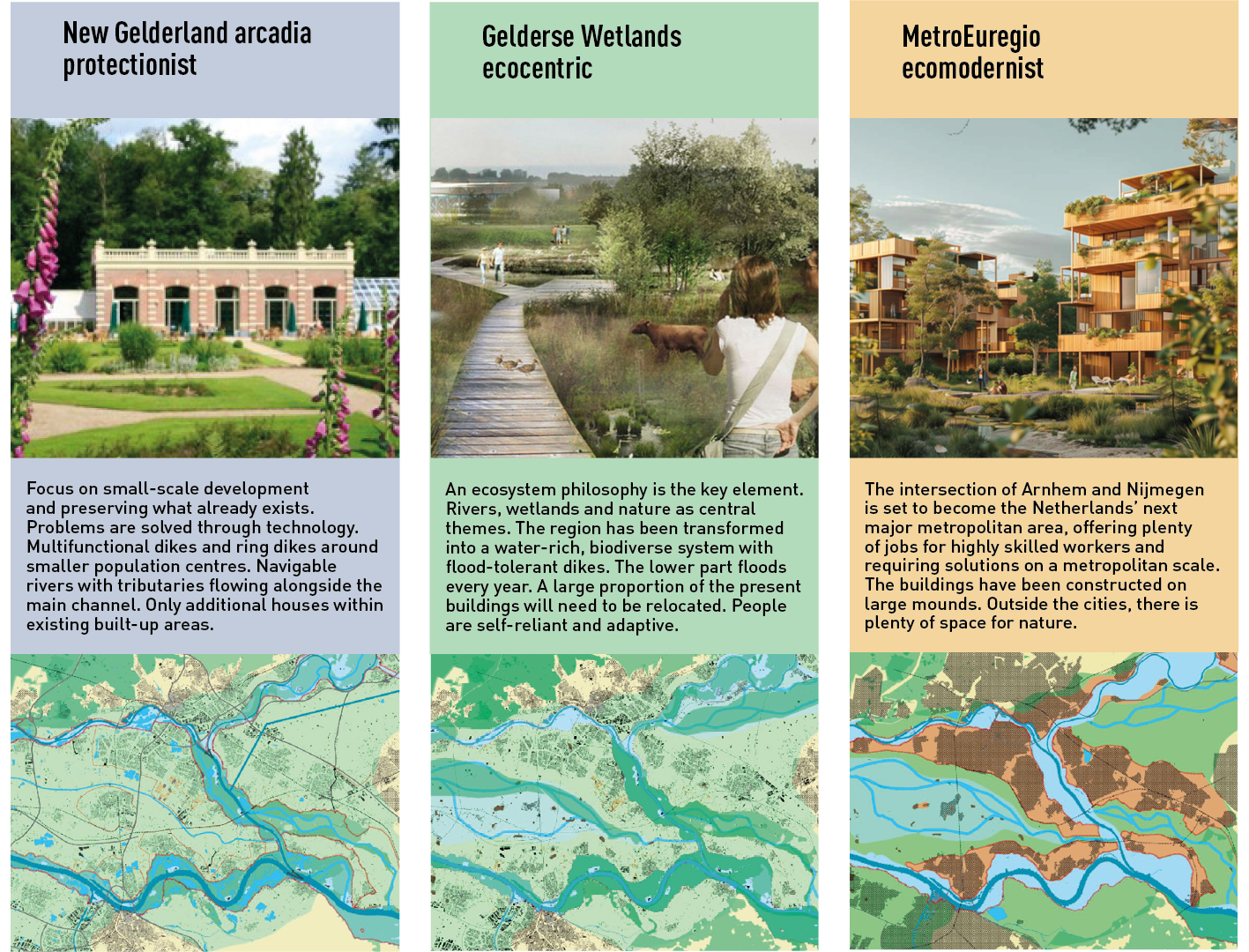 Figure 1. Visions for the future of the bifurcation area [6]
The fifth step was to consider the conditions needed to bring about the three ‘possible futures’. Does public support for the chosen futures and building blocks need to be increased, does legislation need to be amended, or does new technology still need to be developed? And how long will these steps take? Step 6 involved reasoning backwards from the future visions to the present. What routes can we identify? Which areas must be protected at all costs in order to keep the paths to possible futures open? This resulted in the strategic adaptation roadmap shown in Figure 2.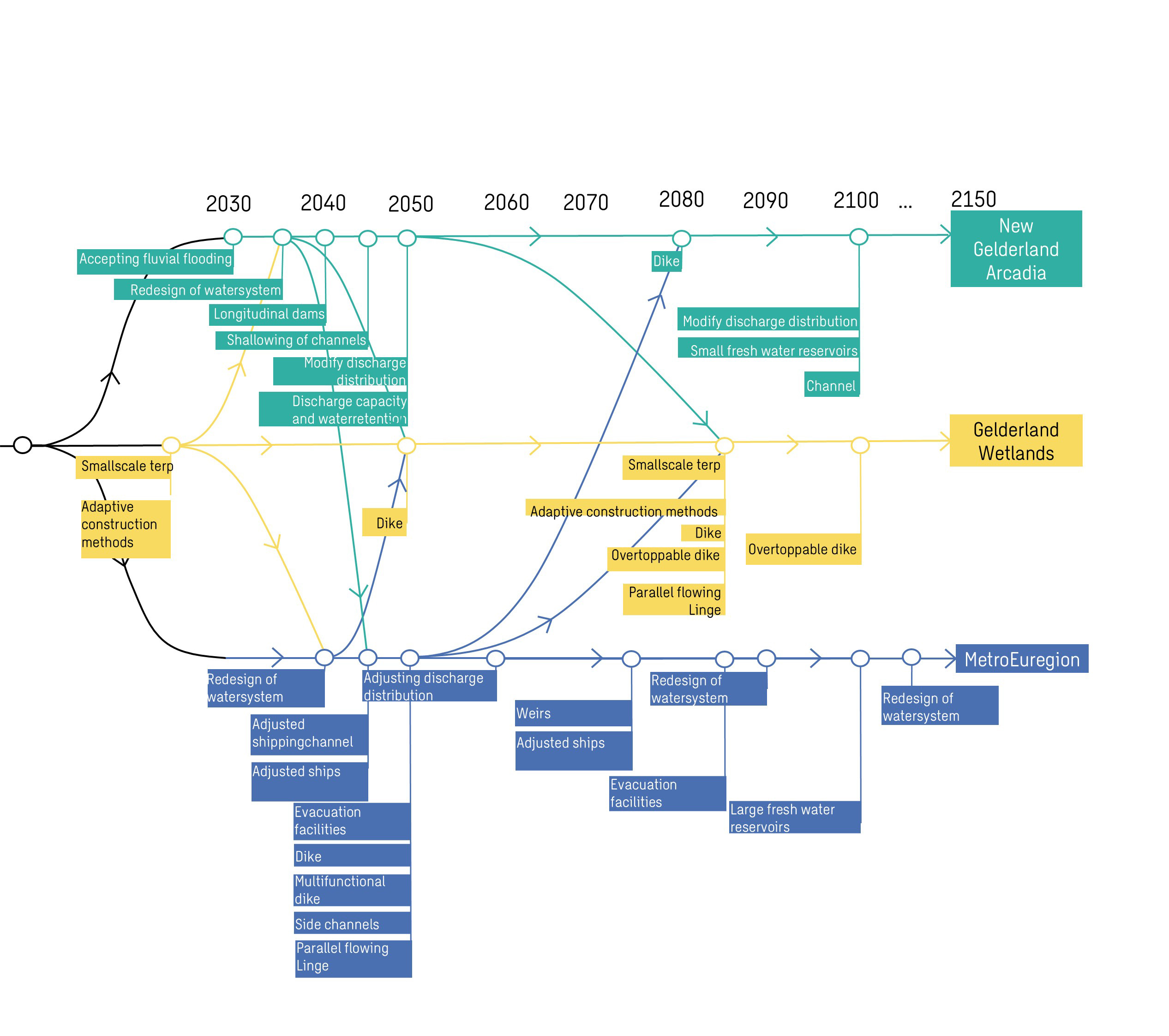 Figure 2. Strategic adaptation roadmap for the bifurcation area
Switching to one of the other perspectives partway through is easiest from the Wetlands vision. From this vision, we can begin to accept more water in the area behind the dikes without having to invest upfront (for example in removing dikes and relocating villages). These steps can be taken at a later date if necessary. If this does not work well, however, it is possible to switch to ‘New Gelderland Arcadia’ or ‘MetroEuregio’. The dikes in New Gelderland Arcadia are a ‘light version’ of those in the MetroEuregio. It is more difficult to switch from the MetroEuregio vision to New Gelderland Arcadia or the Gelderland wetlands, as significant investments will have already been made. The map shows that switching after 2080 will be difficult regardless, since many of the necessary measures will already need to have been implemented by that time.
Conclusions and next steps
The method outlined here clearly illustrates the risks that water authorities are warning about if spatial planning policies remain unchanged. For those involved in spatial planning, it becomes clear when intervention points are likely to arise in the future – in other words, how long their plans are likely to remain viable under an extreme climate scenario. Concrete steps can be taken to implement measures that are ‘no regret’ in the short term. The method also highlights which choices are likely to exacerbate future bottlenecks and where administrative or societal decision-making is required to set aside sufficient space for water in good time.
The landscape units within the bifurcation area that require long-term protection are the Rijnstrangen and the area around the Linge. Plans are already in place to use the Rijnstrangen as an emergency overflow channel after 2050. A Rijnstrangen dike is therefore a no-regrets measure. Allowing the Linge to flow into the major rivers during periods of high water also appears to be an interesting option from several perspectives. It seems sensible to set aside some space for this and to carry out exploratory studies (including calculations). It also became clear which current developments in local spatial planning call for critical discussion. In the area studied, such developments include the strong trend towards urbanisation between Arnhem and Nijmegen. The ‘MetroEuregio’ is an extremely expensive plan that we are already working towards in practice – perhaps without really intending it. After all, if policy remains unchanged, this situation will arise of its own accord.
In 2023, it was found that multi-layer safety measures are being implemented in only 5% of current flood protection projects. Obstacles include a lack of financial and legal frameworks, as well as clear methods for integrating long-term water management objectives into short-term spatial planning objectives. The Flood-Resilient Landscapes approach covers all of these aspects. This methodology has been applied to the Rhine bifurcation area in six regional workshops.