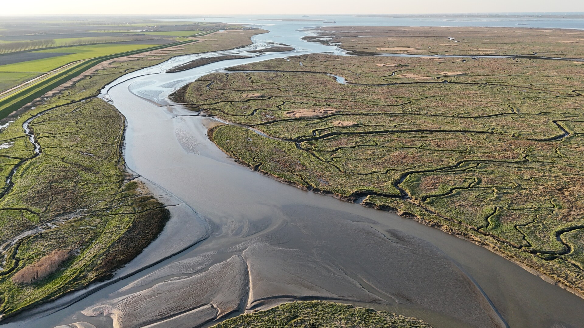
Drowned Land of Saeftinghe. Natural vegetation development that co-evolves with sea level rise | Photo: Thijmen van Heerde/ARK Rewilding Nederland

Drowned Land of Saeftinghe. Natural vegetation development that co-evolves with sea level rise | Photo: Thijmen van Heerde/ARK Rewilding Nederland



Flood protection in the Netherlands has traditionally relied on strengthening and raising dykes. Looking further ahead, the Dutch Sea-Level Rise Knowledge Programme (SLR KP) has outlines three adaptation strategies: 'protect’ by holding the line, 'advance’ going seaward and 'accommodate' by living with the water. The first two strategies suggest that it remains technically feasible to protect the Netherlands from flooding, even under accelerated sea-level rise up to around 2 metres in 2100 and 5.4 metres in 2200 [1].
It is also clear from these exploratory studies that a flood-protection strategy focused solely on engineering measures would have major consequences for coastal and estuarine ecosystems. As sea levels rise, many of these ecosystems are increasingly squeezed between the sea and fixed flood defences. Measures such as closing tidal inlets, maintaining fixed water levels, or creating coastal freshwater lakes reduce tidal dynamics, sediment transport and gradual transitions between fresh and saline environments. This will lead to the loss of valuable habitats and the natural processes that sustain them, while also diminishing the benefits these ecosystems provide for flood protection, freshwater resources, fishing and recreation.
To address this tension, the SLR KP has developed a fourth perspective: 'nature-based' [2]. In this perspective, natural processes and ecological objectives are considered an integral part of long-term flood protection. Intertidal flats, salt marshes and tidal wetlands, beaches and dunes can capture and retain sediment, allowing the landscape to build vertically and keep pace with sea-level rise (Figure 1). These ecosystems can also attenuate waves and reduce the impact of flooding, thereby contributing to a broader and more resilient flood-defence system [3]. To explore where this approach offers opportunities, we examine areas where natural sedimentation contributes to land-level rise and flood protection.
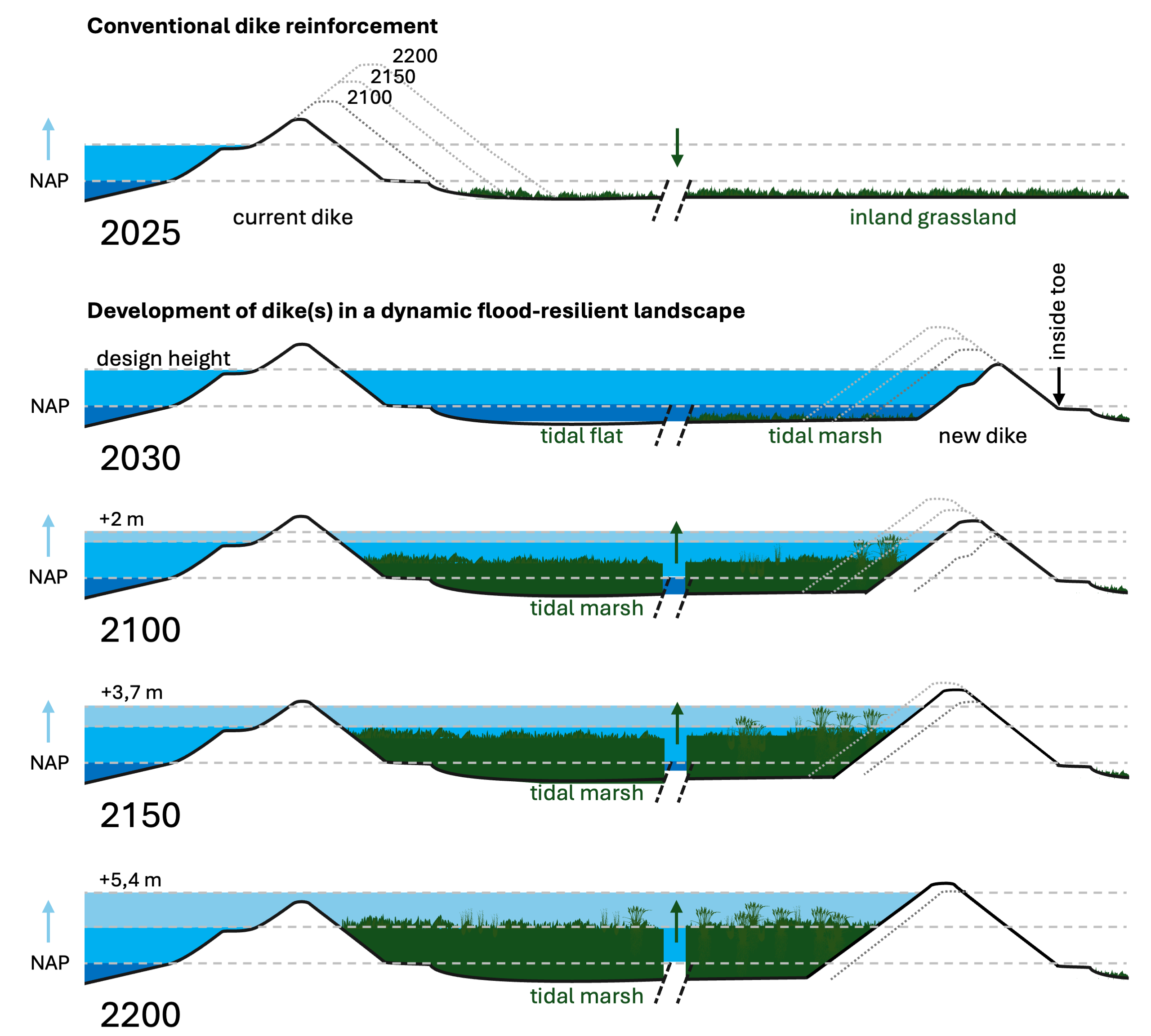
Figure 1. Schematic representation of a co-evolving landscape: foreshore, double tidal marshes and one or more dykes function together as a single flood protection system
Lessons from the past
Historically, Dutch coastal and estuarine landscape ware able to adapt naturally to environmental change. Salt marshes, mud flats and dunes captured sediment, increased in elevation and, where space allowed, migrated landward.
Over the past centuries, particularly during the last 80 years, this capacity has been substantially reduced [2]. Flood protection has increasingly relied on hard engineering interventions such as dykes, dams, storm surge barriers and fixated embankments. While these interventions have greatly improved flood safety, they have also constrained the natural processes that enable landscapes to adapt (see Table 1). In many cases, opportunities for sediment accumulation and landward migration have disappeared, tidal dynamics have weakened, sediment supply has declined and natural freshwater-saltwater transitions have been lost.
In the Southwest Delta, for example, only about one-third of the original intertidal area remains. Freshwater-saltwater transitions have largely disappeared. In the Eastern Scheldt, the storm surge barrier has created a persistent sediment deficit, resulting in the annual loss of approximately 80 to 100 hectares of sandbanks, mudflats and salt marshes. This also leads to the loss of intertidal foreshores that attenuate waves and reduce the hydraulic loads on dykes. The Western Scheldt still retains natural tidal dynamics, but the system is under increasing pressure from land reclamation, channel deepening and embankment reinforcement.
Key conditions
The ability of coastal and estuarine landscapes to keep pace with sea-level rise depends on three key conditions: tidal dynamics, sediment availability and space. Open systems with an unrestricted tidal regime continuously transport sediment and naturally rebuild intertidal areas following erosion. Adequate supplies of sand or silt are essential for maintaining and increasing surface elevations. Where sediment availability is insufficient, active sediment management, such as sediment nourishment, may help restore the sediment balance.
Space is equally important. Sedimentation, ecological development and the landward migration of coastal and estuarine habitats all require room to occur. Without sufficient space, the natural processes that enable landscapes to keep pace with sea-level rise become constrained.
Where these conditions are met, natural landscape development can contribute significantly to adaptation. The loss of this adaptive capacity is therefore not an inevitable consequence of sea-level rise, but largely the result of human interventions and design choices. Conversely, the same conditions provide clear opportunities for restoring and strengthening the ability of coastal and estuarine systems to adabt.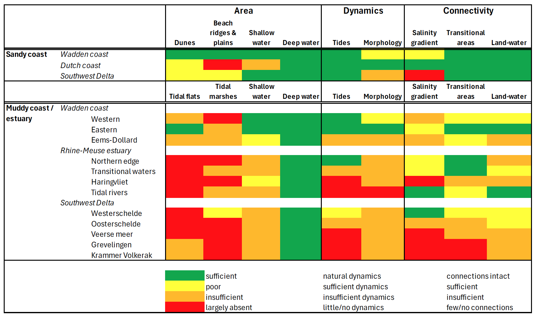 Table 1. System characteristics of estuarine and coastal landscapes in the Netherlands
Where can adaptive landscapes develop?
Open estuaries such as the Western Scheldt demonstrate that natural landscapes can keep pace with sea-level rise. In the Drowned Land of Saeftinghe, for example, measured sedimentation rates are approximatly 5 to 10 mm per year, with locally higher values. Historical records show that surface elevation in this area has increased faster than mean high-water for more than a century.
Rapid sediment accumulation is also observed in recently restored tidal areas such as the Hedwige-Prosperpolder [4] and Perkpolder [5]. Once tidal exchange and sediment transport are re-established, these areas begin to accrete quickly. Model studies indicate that widespread drowning would occur only under rates of rise of sea-level rise op approximatly 15-20 mm per year, well above current projections [4]. These examples demonstrate the significant land-building capacity of natural sedimentation processes.
The Wadden Sea and the Ems-Dollard also have considerable potential. Sedimentation rates can be high, particularly in silt-rich environments [6], [7].
By contrast, systems with limited tidal exchange, such as Waterdunen in the Western Scheldt and Rammegors in the Eastern Scheldt, tend to experience lower sedimentation rates because of reduced hydrodynamic activity and sediment supply. As a result, these systems depend more heavily on management and maintenance. In the Eastern Scheldt, the storm surge barrier has created a persistent sediment deficit, causing sandbanks, mudflats and salt marshes to decline for decades. Consequently, the capacity of these landscapes to adapt naturally to sea-level rise is limited.
How far can adaptive landscape keep space?
The examples above show that sediment-rich coastal and estuarine landscapes can keep pace with present-day sea-level rise. Even under the most likely scenarios for 2100, involving approximately 0.5 to 1 m sea-level rise [7], natural sedimentation processes appear sufficient in many locations, provided that adequate space, tidal dynamics and sediment supply are available.
Under more extreme scenarios, including the 2 m scenario explored by the SLR KP, natural sedimentation alone is unlikely to be sufficient everywhere. In such cases, additional sediment input may be required through measures such as sediment nourishment. Adaptive flood-resilient landscape should therefore not be viewed as a replacement for dykes and flood-defence infrastructure, but as a complementary component of a broader flood-protection strategy that enhances resilience and adaptability. Table 2. Open systems show a significantly greater ability to adapt than systems with reduced tides
Implications for flood protection practice?
In practical terms, opportunities lie primarily in:
Sea-level rise, land subsidence and future dyke reinforcement programmes will increase the demand for wider coastal and estuarine flood-defence zones. Reserving space at an early stage can help avoid repeated interventions and create opportunities for more cost-effective and adaptive solutions [2].
Along the Dutch coast, experience with dynamic coastal management and large-scale nourishments already demonstrate how natural processes can be used to support flood protection. Similar principles can be applied in sediment-rich estuarine systems, although the measures and scales involved may differ. Where natural sedimentation temporarily provides insufficient, targeted interventions can supplement the process. In this way, flood protection remains flexible and adaptive, combining engineered defences with landscapes that continue to develop naturally over time.
Conclusion
Adaptive coastal and estuarine landscapes offer a practical way to combine flood protection with ecological restoration while increasing resilience of the Dutch coast and delta. Existing examples demonstrate that this approach can be effective where sufficient space, tidal dynamics and sediment are available. These principles can already be incorporated into current dyke reinforcement and flood-protection projects, providing a concrete pathway towards more adaptive long-term management of sea-level rise.
The Dutch Sea-Level Rise Knowledge Programme concludes that the Netherlands can maintain flood safety under even extreme sea-level rise scenarios through large-scale engineering measures. Yet such approaches may substantially alter coastal and estuarine ecosystems by constraining the natural processes in which they depend. This article explores how adaptive coastal and estuarine landscapes can contribute to future flood protection through nature-based approaches. These landscapes such as mudflats, salt marshes and dunes can capture sediment, gain elevation and strengthen flood-defence zones while supporting ecological functions. Examples from the Netherlands shows that these adaptive landscapes can keep pace with sea-level rise where sufficient tidal dynamics, sediment supply and space are available.